Mary’s Pilgrimage Route is a part of the international cultural pilgrimage route of the same name leading from Częstochowa in Poland through Levoča in Slovakia to Mariazell in Austria, and then through Graz to Slovenia, continuing to Croatia. The 409 km long route in Slovenia and 393 km in Croatia is intended for pilgrims, hikers, and all who like nature and cultural heritage and want to experience yet undiscovered, interesting places.
Three stages of the first version of this route, running from Trate on the Slovene-Austrian border to Bistrica ob Sotli, go through our destination. A detailed description of the route and its three stages can be found in the enclosed files.
The route is managed by Kozjanski park.
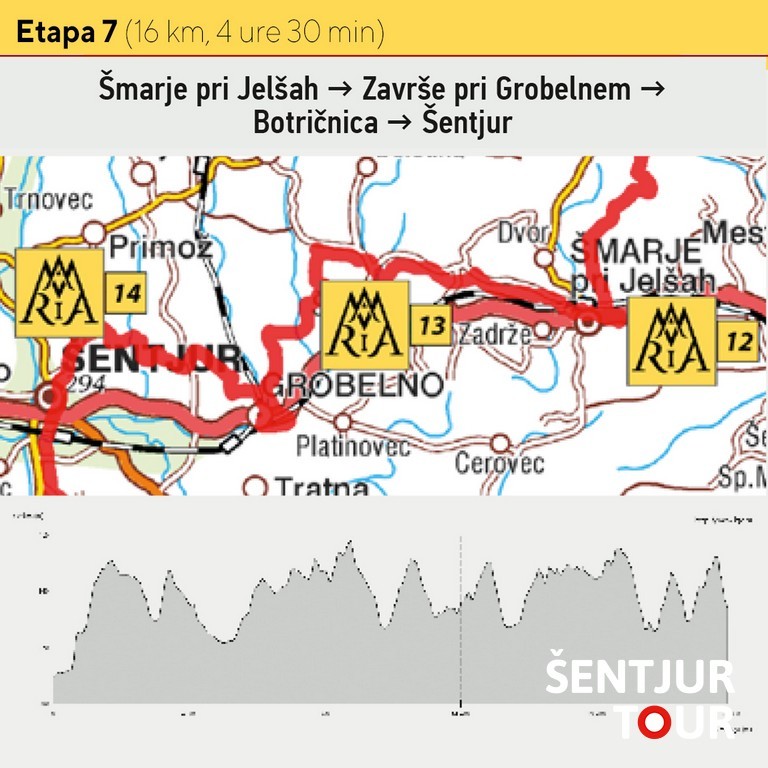
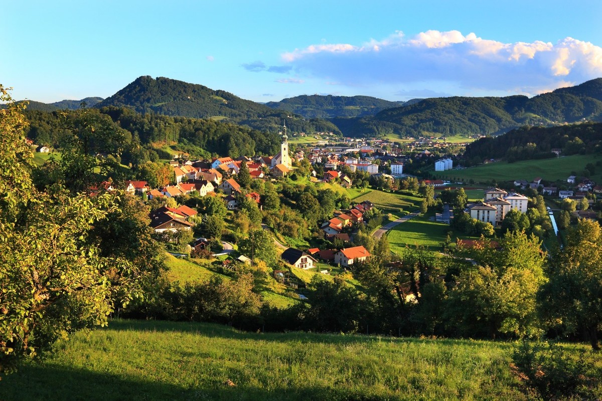
The 7th stage: Šmarje pri Jelšah–Završe pri Grobelnem–Botričnica–Šentjur
From Šmarje pri Jelšah, head back to the railway overpass. Before the overpass, turn left along the street to the intersection before the railway crossing. Continue right over the railway crossing, then turn left along the road toward Jelše Castle. Walk past the castle to the end of the asphalt road, then continue along a gravel road to the intersection in Spodnja Ponkvica. At the intersection, turn right along the road to the wooden bus stop in Podgaj. At the bus stop, leave the road and go left along a cart track past a farm through the fields. Continue along the track to the forest edge, where you turn left into the forest. The trail leads through the forest to an older house and the asphalt road in Spodnje Selce. Follow the road down to the intersection, then turn left along the valley to a larger farm. From here, head right uphill along the hill to the intersection with the road from Ponikva and Slom. Turn left along this road to the Marian Church in Završe, offering a beautiful view of the surrounding landscape.
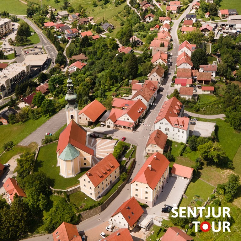
From Završe, descend along the road to a wooden garage, then turn right onto a cart track into the valley leading to the Maribor–Zidani Most railway. At the railway, turn left along the road, then at the intersection, turn right and pass under the overpass through the center of Grobelno. Continue to the railway crossing, then before it, turn right along the road to Grobelno railway station. At the station, take the underpass beneath the Maribor–Zidani Most railway, cross the bridge, then turn right. Continue under a road underpass and follow the road along the railway north to a larger farm. At the farm, turn left onto a gravel road that climbs uphill. On the ridge, join the asphalt road and turn right uphill to the farm, then continue to the end of the asphalt road, where the path joins a cart track. Continue straight along the track through the fields to the hamlet of Spodnji Vrh. At the junction, continue straight along the cart track, which turns left along the grassy slope. On the ridge, enter the forest and descend to an asphalt road. Follow the road right to the junction where our path turns left onto a forest cart track. Through the mixed forest, descend along the hillside to the asphalt road. Cross stream Kamenski potok and continue uphill to the hamlet of Gorica. At the junction, turn right along the road, then shortly leave it, taking the left cart track to the asphalt road. Turn left and soon reach the Mary of Seven Sorrows Church in Botričnica. From the church, continue downhill along the road to Zgornji trg (Upper square) in Šentjur. The Marian Pilgrimage Route passes the birth house of the Ipavec composers and the Church of St. George. Descend the hill to the Dramlje–Šentjur main road.
Short summary: Stage 7 of the Marian Pilgrimage Route
- Easy hiking trail, 16 km
- Duration: 4 to 5 hours
- Follow the yellow trail markers
- In Šentjur, you can visit the Ipavec House Museum, the Rifnik and its treasures museum collection, and the memorial room of the New Swing Quartet – “The Song of the Southern Railway”
- Along the route, there are several inns and bars:
- Grobelno: Bar Kincl, Bar Delfin
- Šentjur: Gostilna & Catering Pri Katrci, Inn Bohorč (both offering food)
The 8th stage: Šentjur-Rifnik-(Slivnica pri Celju)-Kalobje-Dobje-Planina pri Sevnici
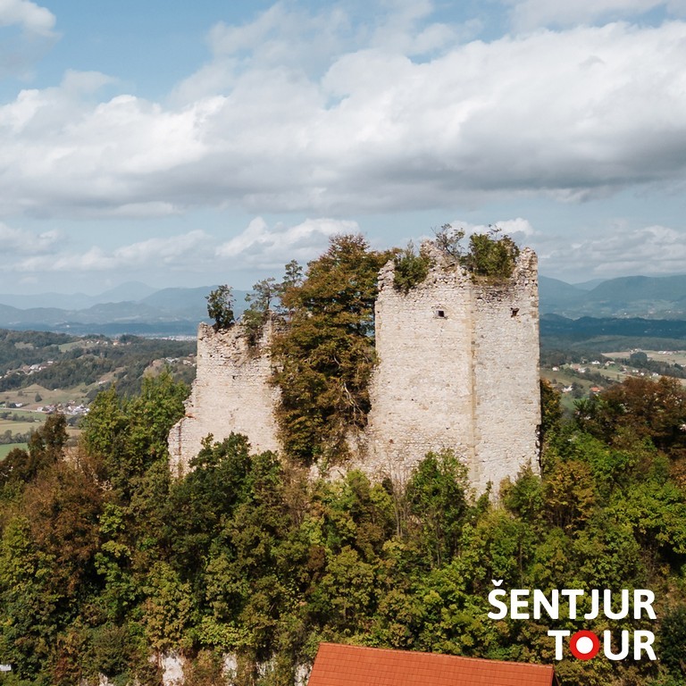
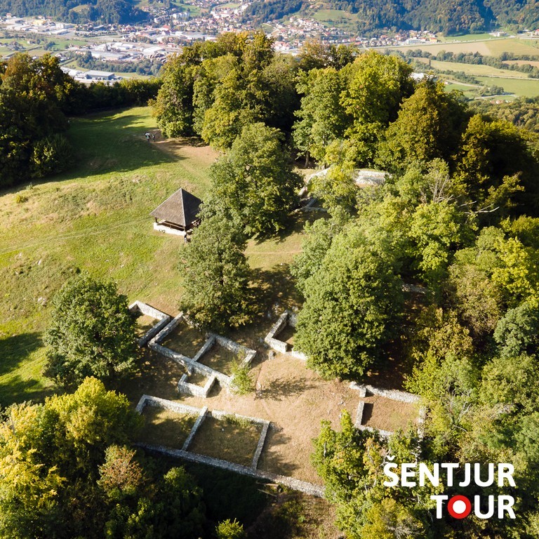
From Šentjur, the trail continues in the direction of Rifnik. At the main road Dramlje–Šentjur, turn left at the traffic-lighted intersection into the center of Šentjur. At the traffic lights, continue straight along the sidewalk, through the underpass under the railway, to the Šentjur industrial area. From the intersection in Šentjur to the top of Rifnik, the route is marked with white-and-red Knafelc trail markers. At the roundabout, take the exit for Rifnik and continue straight to the foot of Rifnik Hill. At the wooden bus stop, turn left up the stairs to a residential house. Follow the forest path uphill to the asphalt road. Turn right along the road, passing houses and continuing through the forest to the intersection where the road to the Rifnik Castle ruins branches off to the left. Continue right along the cart track uphill toward the summit of Rifnik. On the summit ridge, the mountain trail branches to the top of Rifnik, where the archaeological site with the largest Late Antique settlement discovered in Slovenia is located. Continue right past the water intake downhill to the road junction, then turn left along the road downhill. From this trail branch before the water intake to Podsreda Castle, follow the round white-and-yellow markers for the Marian pilgrimage hiking trail.
Passing between houses and individual vineyard cottages, descend to the bend by the chapel (watch for the marker on the slope), leave the asphalt road, and turn left along the driveway to a farm at the edge of the forest. Continue uphill through the forest to the asphalt road leading to Kalobje. At the junction by the wooden cross, go straight up the road to the top of the hill, where the Pilgrimage Church of the Virgin’s Name in Kalobje stands. From the top of Kalobje, continue along the road across the hill ridge, gradually descending to the forest edge. Here, turn left onto a cart track, descending through the forest and along the meadow edge back to the asphalt road. Follow the road left through the village of Kostrivnica to the right-hand branch, where leave the asphalt road and continue along the forest road past the Frece homestead to the main road Šentjur–Planina pri Sevnici. Cross the road carefully and at the first branch turn left uphill. Ascend along the slope of Laze Hill, past the cemetery, to the center of Dobje pri Planini, where the Church of Virgin Mary stands. From the church, return a few meters to the junction, then continue straight uphill along the road. Follow the panoramic road to the branch in the village of Ravno, where turn right. First through the forest, then past scattered houses, descend into the village of Ravno, where turn left along the road to the end of the asphalt. Continue along the gravel road, first through fields, then through the forest called Ravenski Log. When reaching the asphalt road in Brdo, go straight downhill into the Gračnica valley and carefully cross the main road. Along the old forest road, ascend to the center of Planina pri Sevnici, beneath the ruins of the Planina castle.
Extension to hill Slivnica pri Celju
On the southern slope of Rifnik, a variant of the Marian Pilgrimage Route branches off through Gorica pri Slivnici and Slivnica pri Celju. It rejoins the main route at Kalobje. The trail toward Gorica initially follows a cart track that descends along the hillside through forest and meadows, passing individual houses to the Voglajna valley, reaching the road Šentjur–Kalobje. Along the main road, turn right and take the first left onto a local road. Follow this winding road past houses to the Church of St. Urban and descend past the primary school to the center of Gorica pri Slivnici. From the village center, continue along the main road toward Kozje. A few meters past the intersection with the road to Voglajna, turn right across a small meadow into the forest. Ascend along the path to a weekend house with a small vineyard. Continue along the gravel road to the asphalt road leading to Slivnica. From here, turn right to the Church of St. Mary Magdalene in Slivnica pri Celju. Return past the water trough a few meters to the branch of the local road, continue left to the end of the asphalt, and then along the gravel road. The panoramic road runs fairly level along the hillside, offering wide views to Pohorje, Boč, and Donačka Gora. Continue to the hamlet of Sele, then descend along the asphalt road to the valley, where the main Šentjur–Planina pri Sevnici road runs. At the nearby inn, cross the main road and continue straight along the local road into a small valley. At the end of the asphalt, turn right onto the gravel road uphill. Soon you reach the houses of the village of Trno. Pass the chapel to the junction with the road where the Marian Pilgrimage Route from Rifnik to Kalobje continues.
Short summary: Stage 8 of the Marian Pilgrimage Route
- Easy to moderately challenging hiking trail, 18 km, with the extension to Slivnica pri Celju 27 km
- Duration: 4 to 5 hours, with extension to Slivnica pri Celju 8 hours
- In Planina pri Sevnici, by prior arrangement, you can visit the Planina Museum – Šmid Ethnological Collection and the permanent World war II exhibition Kozjansko Glows
- Along the route, there are several inns and bars:
- Šentjur: Inn Gostilna & Catering Pri Katrci, Inn Bohorč, Pizzeria Osmica, Café Lipa, Jana Sweet Shop
- Gorica pri Slivnici: Inn Ana Lesjak, Café Aurea
- Dobje pri Planini: Gostilna pri Olgi
- Inn Planina pri Sevnici: Hiša Wambrechtsamer, Café Bar As
- Along the route, there are several self-service stores:
- Šentjur: Market Resevna (Mestni trg 4)
- Gorica pri Slivnici: Trgovina Kea
- Planina pri Sevnici: Trgovina Kea
The 9th stage: Planina pri Sevnici–Zagorje–Kozje–Podsreda
From the center of Planina pri Sevnici, continue along the sidewalk to the main road Šentjur–Sevnica. At the intersection by the gas station, turn left to the nearby branch of the local road on the right toward the cemetery. Follow this road uphill to a production facility. In front of the facility, turn right toward the hamlet of Dvor. Pass between the houses to reach a cart track, which leads to the first station of the Chapels of the Stations of the Cross. In the switchbacks between the Way of the Cross stations, ascend the steep slope to the Church of Holy Cross. From here, a wide view opens over much of eastern Slovenia.
From the church, continue along the flat terrain to the first houses in the village of Lipa. Here, step onto the road and continue downhill to the hamlet of Jelše. In the hamlet, leave the asphalt road and descend left along the cart track at the edge of the pasture into Šentvid pri Planini. At a farm building, step onto the asphalt road, turn left, and continue to the Church of St. Vitus. From the center of Šentvid, turn left along the local road toward the settlement of Podpeč. Walk along the fairly level road. To the left, the slopes of Pečine rise above us, while to the right lies the forested Bohor ridge. Not far from Podpeč, a signpost directs us right down a gravel road into the forest. Through the forest, reach a solitary homestead. Take the cart track to the right under the buildings into the valley of the Laniška stream. When reaching the forest edge, stay right. Soon, reach the crossing over the Laniška stream. After crossing the stream, begin ascending along the cart track, first through the forest, then alongside a pasture to the ridge, where you reach an asphalt road.
Turn right along the road toward a larger farm; continue slightly downhill on the road to Zagorje pri Lesičnem. The Church Mary Help of Christians in Zagorje remains visible ahead. At the junction near the transformer station, turn right into the center of Zagorje. From the Marian Church, descend along the road to the left-hand branch toward the Lurška Cave. Reach cave Lurška jama via a cart track downhill through the forest. Soon, in the middle of the forest, a beautiful grotto with the altar of Our Lady of Lurška opens up. Follow the circular forest path above the grotto back to the asphalt road. The Marian Pilgrimage Route continues down the asphalt road to the junction with the Lesično–Planina road. Carefully cross the main road and continue straight along the gravel road toward the forested slopes of Bohor. Initially, the road passes through grassy slopes to the forest edge. Through the forest, ascend to the junction of gravel forest roads. Turn left along the road, which runs along the northern slopes of Bohor. Occasionally, there are views to the left over Zagorje and the valley below.
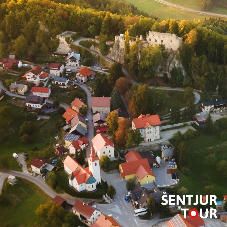
At the ridge, a gravel road joins from the right, part of the XIV Division hiking trail from Bohor to Lesično. At the junction, turn left along the ridge to the solitary Tovornik homestead. At the homestead, the gravel road continues right downhill into Bistri Graben. Continue straight along the ridge road past the Tovornik homestead. Along this road, reach the junction where the XIV Division hiking trail branches left to Lesično. Take the right-hand path along the gravel road downhill. The road descends into Bistri Graben, reaching an asphalt road. At the junction, turn left along the asphalt road to the center of Kozje, where the parish Marian Church stands. From the center of Kozje, turn right to the main Bistrica ob Sotli–Planina road. Carefully cross at the first pedestrian crossing (just past the gas station). Then continue straight along the local road to a nearby junction and turn left past the health center uphill. Here, turn right through a newer neighborhood uphill. Between the houses, reach the gravel road, ascend to the ridge, and at the chapel, reach the asphalt road. Turn left slightly downhill and shortly after, at the cross, leave the asphalt road and turn right along the path across the meadow to the Dupla stream. On the other side of the stream, quickly reach the asphalt road and turn right. At the nearby junction, turn right into the Dupla valley. Initially on asphalt, then on gravel, walk along the narrow valley of the Dupla stream to the settlement of Socko. Upon reaching asphalt, go straight to the main Bistrica ob Sotli–Kozje road. Follow the road left, then shortly turn right onto a gravel road passing individual houses. At the end of this road, rejoin the main road. At the first branch, turn right along the local road to the center of Podsreda. Crossing the main road to the left, you can reach the Chapels of the Stations of the Cross, which leads uphill to the hill with the Marian Church, called Stare Svete Gore above Podsreda. In the center of Podsreda stands the Church of St. John the Baptist and the seat of the Kozjanski park.
Short summary: Stage 9 of the Marian Pilgrimage Route
- Easy hiking trail, 24 km
- Duration: 7 hours